[
Homepage ] [
Introduction ] [
Warning ] [
Ratings
] [ Ethics ] [
Feedback ] [
Updates ]
 |
Parowan Gap
Parowan Utah
Rock Art & Dinosaur Tracks
The
Parley Pratt Expedition discovered the petroglyphs at Parowan Gap in
1849. The pass is a classic example of a wind gap, an unusual geological
landform marking where an ancient river cut a 600-foot-deep notch
through the mountain. Native Americans used this ancient gap for
thousands of years to provide easy passage through the Red Hills.
The north wall of Parowan
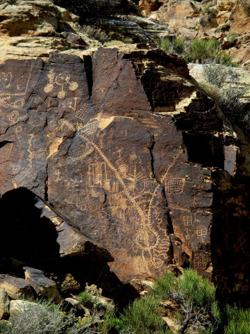
Gap contains a huge gallery of Native American rock art. Most petroglyph
sites contain figures of humans and animals. This petroglyph site
contains many deeply inscribed geometric forms, along with some humans
and animals. The most interesting feature of this site is a very large
and deeply inscribed petroglyph known as the "Zipper". Many
archaeologists believe the "Zipper" is a composite map (space) and
numerical calendar (time). |
General Information:
  This is an enjoyable adventure for all ages. This complete journey will
require approximately one hour. Please take nothing but pictures and leave
nothing but footprints.
A GPS is
a complete waste of time but I have included the waypoints for the
electronic junkies. The USGS 7.5' Map
titled "Parowan Gap" shows the area
described. Navigation for this route is extremely easy as it's a roadside
stop with short signed trails. All
waypoints and maps use the WGS84 datum.
Directions from
Parowan, Utah:
Travel
down Parowan Main Street and turn west on 400 North (Gap Road). Follow this road
8.4 miles to the Dinosaur Tracks (N37° 53' 49", W112° 57' 03"), which are
signed and located on the north side of the road. To
reach the petroglyph site drive west and additional 2.1 miles
to the signed Parowan Gap Petroglyphs (N37° 54' 35", W112° 59' 08").
Directions from Cedar
City, Utah:
Take I-15 Exit #62 (Enoch/Minersville),
turn west and follow Highway 130 (Minersville Highway) as it swings north.
Follow Highway 130 for 13.2 miles to mile marker 19.4. Turn east (right) on
12800 North (Gap Road) and follow the paved road for 2.4 miles to reach the
signed Parowan Gap Petroglyphs (N37° 54' 35", W112° 59' 08"). To reach the
dinosaur tracks drive east an additional 2.1 miles to the signed Dinosaur
Tracks (N37° 53' 49", W112° 57' 03"), located on the north side of the road.
Parowan
Gap Petroglyphs:
Several centuries ago
Native Americans traveling through the area stopped and chiseled designs
onto the smooth faces of large boulders found in the gap. The petroglyphs
are thought to be the work of several cultural groups and represent a long
period of use by Native cultures. What these designs mean is still unknown.
Archaeologists debate that they represent concepts, ideas or actual
happenings.
While we don't know the
precise age of these petroglyphs, we do know that the agriculturally based
Sevier-Fremont lived in the area over a thousand years ago. There is little
doubt that some of the designs were made by this group, or perhaps even the
earlier nomadic Archaic peoples. Researchers believe that the semi-nomadic
ancestors of the present day Southern Paiute also created some of these
figures.
Parowan Gap Dinosaur
Tracks:
The dinosaur tracks
(natural casts) occur in the Iron Springs Formation and are usually in the
fallen blocks of light yellow-brown sandstone. Some tracks do occur in
place, but most are in the large fallen boulders, so check them first.
Originally, these footprints were made in non-resistant mudstones which have
since eroded away to expose the sandstone cast.
Most of the tracks at
Parowan Gap were made by Hadrosaurs, which was one of the most abundant
dinosaurs in North America. The tracks contain three toes and resemble giant
bird feet. Hadrosaurs, nicknamed "duck-billed" dinosaurs, spent their day
grazing much like a modern day cow. They weighted a couple of tons and were
10 to 40 feet long.
[
Homepage
] [ Introduction ] [
Warning ] [
Ratings ] [
Ethics
] [ Feedback ] [
Updates ]
© Copyright
2000-, Climb-Utah.com |